A Digression
Perhaps Celebration Park’s biggest attraction is Guffey Railroad Bridge. It was built in 1897 for the Boise, Nampa, and Owyhee railroad, intended to carry ore from Silver City to Nampa for smelting. However construction of the track never made it further south than Murphy and was used instead by the farming community. It was “abandoned in 1947, saved from demolition in the 1970s, and purchased and restored by Canyon County in 1989”(1) as part of Celebration Park. It now connects Owyhee and Canyon counties via a rail trail suitable for walking, biking, and horseback riding, providing a rare opportunity to cross the Snake River without getting wet. The nearest bridge is about 4 miles downstream at Walter’s Ferry.
The combination of drinking water, legal camping, and easy access to highway 78 via Guffey Bridge was irresistible. To complete this tour in the time we had available, we had to get from Boise to Bruneau in two days and the intermediate stop needed to be far enough down the road to avoid a 70+ mile day to Bruneau, a distance that I thought was out of range for our group. I considered Given’s Hot Springs but it put Bruneau north of the 70 mile mark and added about 20 unnecessary miles to the trip. I considered adding the roughly 12 additional miles necessary to get from Celebration Park to Highway 78 via Walter’s Ferry, but that’s even worse. Besides, bike routing on Google Maps showed a route from Celebration Park to Highway 78 across Guffey Bridge. For quite awhile that was the plan.
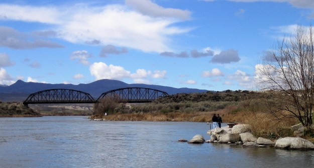
Guffey Railroad Bridge

Looking Upstream from Celebration Park
But was it really possible to travel the 2 miles from Guffey Bridge to Highway 78 by bike? I had my doubts. A couple of weeks before the tour, a friend and I drove down to Celebration Park with a bike, trike, two dogs, and a trailer to see for ourselves. The ride from the park and across the bridge was perfect. Then, immediately on the south side of the bridge we encountered some foreshadowing of troubles to come: a sizable ditch that looked quite intentional. The purpose of the unsigned ditch was quite ambiguous—did Canyon County really spend all that money to restore a bridge that could only be accessed from one side? There were myriad trails crisscrossing the desert on the south side of the river and no indication that bikes weren’t allowed. We carried trike, bike, and dogs over the ditch and pressed on.
Soon thereafter, the other shoe dropped when we encountered a barbed-wire fence across our beautiful rail trail. We could see the railroad bed continue on past the fence and eventually intersect Guffey Lane, which I knew connected to Highway 78 in short order. I was incredulous and, I’ll admit, a bit ticked off. This 2-mile section might mean the difference between the tour I’d intended and ditching this entire portion of it and it completely trivialized the beautiful bridge we’d just crossed that connects two rural Idaho counties. To what purpose? So that the folks who live along Guffey Lane can fancy themselves a gated community?
Conflict between property ownership and trail development is common. Even in Boise, where the greenbelt along the Boise River connecting Boise, Garden City, and Eagle has been in development for some 50 years and was recently declared “finished”, conflicts remain. The Island Woods and Riverside Village subdivisions are notorious for illegally blocking public access to rights of way along the river. The Riverside Village situation was diffused somewhat when alternative access was provided along the south side of the river and through lightly-traveled neighborhood roads on the north side. Island Woods is still locked in a contentious legal battle with the City of Eagle, in part because there is no good way around it.
Abandoned railway lines are transportation corridors that, like rivers, have a reasonable expectation of public access. Since 1983, the federal government has allowed an alternative to abandonment called rail banking. Ownership is transferred to the state or federal government which keeps the right-of-way and structures intact while removing liability from the railroad that previously owned it. Interested parties like Rails-To-Trails developers can apply to use the land for other purposes, with the agreement that the corridor may be restored to railway use in the future. This makes a lot of sense to me. Railway lines exist because they optimally connect regions and communities together and the costs of engineering, construction, and environmental impact were sunk long ago. As much as I like rail trails, I’d prefer they remain railroads to help offload the long-haul traffic that snarls and degrades our highways. Using the rail beds as trails while railroad use remains economically unviable seems like a good compromise.
Weiser River Trail in western Idaho is a good example of a rail trail that directly benefits from rail banking. Even with the authority of the federal government, the developers of the trail spent a large amount of time and money fighting legal battles from private parties who thought they were afforded squatter’s rights. Not so, it turns out, and Weiser River Trail now provides an 84 mile long non-motorized transportation corridor, from Weiser to New Meadows, ID. You still see signs of dissent along the trail, like a sign near Mundo Hot Springs that says, in effect, “The Weiser River Trail Ruined My Life.”
I’m not a fan of gated communities for a number of reasons but I think it’s simply wrong when they block strategic access to public lands. The situation at Guffey Bridge reminds me of my experience with public beaches in southern California, where adjacent landowners attempt to prevent public access by making it look like the beaches are private. Incidentally, the same tactic was used by John Evans, Mayor of Garden City, ID and former developer of Riverside Village, to renege on a prior agreement allowing bicycle access along the Boise River in Riverside Village. Posting a $2 “No Trespassing” sign is easy and deceitful, but pretty meaningless. But a barbed wire fence? The Boise, Nampa, and Owyhee Railroad was abandoned some 40 years before rail banking became law, so I have no doubt ownership reverted back to the adjacent landowners. Still, when the bridge was restored it’s a shame that an agreement wasn’t reached to connect it the roughly 2000 feet necessary to reach Guffey Lane on the south side of the river.
I’m no Rosa Parks, but fueled by indignation and necessity it was easy to commit a little civil disobedience and hop the barbed-wire fence. We peacefully rode the 4-mile round-trip to Highway 78 and back with nary a look askance from the locals. Now I knew it was possible to cross at Guffey Bridge, but was it a good idea? Well I’d already done it once. I deferred to the group: only one responded, and it was in the affirmative. Crossing at Guffey Bridge was now the plan of record, thus beginning my life of crime.
